+ 2,000 destinations find now !

Showing posts with label baja california. Show all posts

Mexicali is a city ruled, the state capital of Baja California

mexicali baja california

Mexicali is a city ruled, the state capital of Baja California and head of the homonymous municipality. It is the northernmost city in Mexico and Latin America.


Mexicali is located in the northwest corner of the Valley of Mexicali on the border with the United States of America. The city's altitude is variable, this is why areas like Agricultural Islands, located to the east of the city, is 10 meters above sea level, while Santa Isabel, an area west of the urban area is 3 meters below sea level, however, the city's average altitude is about 3 meters above sea level.


This town is known for its agricultural, industrial and tourism, highlighting the activityof the tertiary sector (trade, services and tourism) that absorbs 52.10% of the employed population, in turn 44% is used in hotel and restaurant services . It has 53hotels with a higher offer than 3,000 rooms.

These include two five-star hotels. The capital of the state receives foreign tourists, mainly from the neighboring counties of the United States; who visit us for trade, the maquiladora industry and the food, particularly the famous Chinese food, which presents a variety of options to enjoy

Geographical coordinates: North 32 º 43 'south latitude 30 ° 52'de north east 42'y114 º 115 º west longitude 56'de.

climate


http://mx.clima.yahoo.com/m%C3%A9xico/baja-california/mexicali-133475/


Ver mapa más grande

Tijuana is a city belonging to the Mexican state of Baja California

Tijuana Baja california

Tijuana is a city belonging to the Mexican state of Baja California. It is the most populous of the state and is located 170 km west of state capital, Mexicali and about 60 minutes north of Ensenada. The city is capital of the municipality of the same name and is known among other epithets as the corner of Mexico or the doorof Mexico. Their motto is "Here begins the country"

Tijuana is 32 ° 31 '30 "north latitude and 117 degrees west longitude. It is borderedto the north at 41 miles in the San Diego County (California), south to the towns ofPlayas de Rosarito and Ensenada, East with the municipality of Tecate and west bythe Pacific Ocean. the municipality has an area of ​​1239.49 square kilometers.

The municipality of Tijuana is located northwest of the state, the county seat is located at coordinates 32 ° 32 'north latitude and 117 ° 03' west longitude.


Ver mapa más grande

Ensenada Baja California It was discovered in 1542

Ensenada Baja California

It was discovered in 1542 by a Portuguese navigator Juan Rodriguez Cabrillo, whoupon arriving in this land named "San Mateo", then renamed the "Ensenada de Todos los Santos" when Sebastian Vizcaino arrived in 1602 in a November 2, the day in which Mexico celebrates the Day of All Saints day or the Dead.

It was not until 1870 when gold mines were discovered in Real del Castillo,Ensenada was put on the world map and he developed rapidly. Ensenada waswhen they named the capital of the Northern Territory of California in 1882. In beginning the new millennium mines had been exploited to its maximum capacity, and the capital was moved to Mexicali, returning to be a peaceful people and in itsearly days.

Resorts

The main and most popular resorts are:

Spas: The Glens, located in the ejido The Skunk has two large pools, sports courts,grills, water slide, artificial lake with small boat rental.

The Palomar is in the delegation of St. Thomas, has a large pool, sports courts(tennis, basketball), restaurant, barbecue, sound weekends, etc..
There are also pools Maria Theresa in the Guadalupe Valley, Los Cardenas in the skunk, the resort of Teachers (SNTE) for the Tijuana-Ensenada free road, among others.

The most popular beaches are El Faro (sporting events) and Monalisa are located in the Chapultepec, San Miguel (rocky beach where surfing and camping) in theSauzal Rodriguez, La Joya in Maneadero, etc..) And Bay Angels


Ver mapa más grande

Salsipuedes northern california

Salsipuedes northern california

Latitude. 31.9666667 °, Longitude. -116.7833333 °

In the 1960's, after the opening of Tijuana to Ensenada for the scenic coastal highway, visitors began to notice a sign announcing the highway "Salsipuedes 3 km(1.8 miles) since its release. Spanish-speaking Americans were curious at the as itsname translates as "leave if you can."For those who do not speak Spanish was one of those names with a lot of cards.


Passing the highway sign Salsipuedes, frequent visitors start looking forward to the spectacular view that is about to experience. First time visitors are not prepared forthe beauty of the land and stunning views of carved coastal reefs, islands and blue waters of the Pacific Ocean. For those who visited South Grand Central California in the early 1950 or before, there is an overwhelming sense of déjà vu


Ver mapa más grande


el descanso baja california norte

town of El Descanso is located in the municipality of Playas de Rosarito (in the State of Baja California). Has 263 habitants. Rest is 5 meters.


Ver mapa más grande

la mision , baja california norte

la misión


The Mission is located in the municipality of Ensenada (in the State of BajaCalifornia). It has 1058 inhabitants. The Mission is 20 meters.
The Mission and Mission San Miguel is a town in Baja California, located in Mexican Federal Highway 1 about 40 miles south of Rosarito Beach's "Gold Coast" of thepeninsula of Baja California. The 2005 census reported a population of 1,058inhabitants. The port city of Ensenada is a 40 km or so south of La Mission.

The ruins of Mission San Miguel Arcangel de la Frontera is located near downtown.


Location of the Mission
The Mission is located in the Municipality of Ensenada Baja California Mexico and isin the GPS coordinates:

Longitude (dec): -116.855556

Latitude (dec): 32.094167

The town is at a median height of 20 meters above sea level.


Tecate is a small Mexican town in Baja Californi

tecate

Tecate is a small Mexican town in Baja California state that China has great influencedue to migration in the early 90's, located northwest of the country. Is head of the municipality of Tecate.
The meaning of Tecate is unknown and we only know that this place was named because of its indigenous inhabitants. Some historians place it as cut stone or cuttree, others say that may arise from the Tecate outer layer is very thick and medicinaloak the oak tree is typical of the region.


The flavor of a small community picturesque colonial style, it is Tecate. Tecate is aborder town that does not seem, has extensive views of farmers fields, spectacularmountains and gigantic rock formations. Tecate also is home to renowned brewery.has several spa, with specialized health care recognized worldwide, such as LaPuerta. Exist in the environment of the city paintings (ate prehistoric rock).


Ver mapa más grande


el descanso baja california norte

town of El Descanso is located in the municipality of Playas de Rosarito (in the State of Baja California). Has 263 inhabitants. Rest is 5 meters.


Ver mapa más grande

la mision , baja california norte

la mision is  located in the municipality of Ensenada (in the State of BajaCalifornia). It has 1058 inhabitants. la mision is 20 meters.
la mision San Miguel is a town in Baja California, located in Mexican Federal Highway 1 about 40 miles south of Rosarito Beach's "Gold Coast" of thepeninsula of Baja California. The 2005 census reported a population of 1,058inhabitants. The port city of Ensenada is a 40 km or so south of La Mission.

The ruins of Mission San Miguel Arcangel de la Frontera is located near downtown.


Location of the Mission
The Mission is located in the Municipality of Ensenada Baja California Mexico and isin the GPS coordinates:

Longitude (dec): -116.855556

Latitude (dec): 32.094167

The town is at a median height of 20 meters above sea level.


Ver mapa más grande

cataviña, oasis in the desert , baja california

Cataviña is a small town located on Highway 1 in the Mexican state of Baja California. It is located 125 kilometers south of the town of El Rosario and 110 kilometers north of Punta Prieta Whereabouts, where part of the road to Bahia de los Angeles. The name is originally Cataviña Cochimí, but its significance is unknown.

The local economy depends mainly on tourism, and the Services provided to motorists who drive on the road.

It has a top quality hotel developed by the National Fund for Tourism Development of the Mexican government in its vicinity are some rock paintings and a field of giant rocks, which mixed with desert vegetation make the area a much-visited for ecotourism lovers.


Palmerito The Park is dedicated to the conservation of flora and fauna of Cataviña, central Baja California. Nature trails, a small museum, comfortable sanitary, ecologically planned and allow camping spaces marked for visitors to discover the wonders of the Central Desert and have the opportunity to collaborate in preserving this area for future generations.


paintings
Description
The term "rock art" refers to the paintings and engravings found on rock shelters and fronts and depressions practiced on the surface of the rock, which probably had a ceremonial function for the human groups that performed. Such demonstrations are found mainly in natural cavities and in the safeguards that are stacks of rocks such as granite outcrops.

The designs of paintings that will witness in the central desert area are geometric and anthropomorphic figures are schematic in nature, whose size is variable, but do not exceed fifty centimeters. At several points it is apparent that the paintings are layered with other, indicating that certain places were taken over time for several generations.


Getting there
If you take the Highway Ensenada - La Paz, 372 km south of Ensenada you will find the tourist center of Cataviña, BC The rock paintings are 400 m from the left side of the roadside, just before reaching the hotel La Pinta in this hostel. A 22 km from the inn, east of the highway, is located at Mission Santa Maria de los Angeles Cabujacaamang and Oasis in Santa Maria


Cataviña offers excellent opportunities for mountain climbing, mountain biking or camping. On the road, you'll find The Oasis Santa Maria, where the ruins of the last mission of the Jesuits in the Peninsula (Santa Maria de Los Angeles Cabujacaamag) are largely intact. Other places to see are large concentrations of "Blue Palmas" and La Poza Bracket, a nature reserve located between giant granite rocks.


Paintings

These pictographs were probably made by indigenous cochimíes who lived here thousands of years ago.

There are several theories that attempt to explain the objectives of these early performances of art. These revolve around witchcraft and religious purposes. Other latest matches directly explain that merely served as records of important events.

With radiocarbon testing has been calculated that these petroglyphs were created over 5000 years ago.


El Triunfo, Baja California Sur, México

Located in the mountains south of La Paz on the way to San Jose del Cabo, El Triunfowas once the largest
city in Baja California. Silver was discovered in 1862, attracted people from around theworld and the population rose to
10,000, is now home to a few hundred. The chimney which rises above the landscapeis part of the
Progress Mining Company. The wealth created from mining made the city a culturalcenter, the remainder of this
today is the piano museum, home to the beautiful grand pianos, some of which are stillunder restoration.

San Pedro Martir National Park comprises wooded lot located within the mountainous Sierra de San Pedro Martir

The San Pedro Martir National Park comprises wooded lot located within the mountainous Sierra de San Pedro Martir. This is one of the few tracts of mountain forest is located in the Baja California Peninsula. It has a variety of conifer species and serves as an important refuge for wildlife on the peninsula whose species, some endemic can see bighorn sheep.
Located in the central Mexican state of Baja California, whose area corresponds to the municipality of Ensenada. The area was explored for the first time to 1701 by the expeditions undertaken by Eusebio Francisco Kino, but the Dominican order who founded the first mission in place.

Located 150 kilometers southeast of the city of Ensenada and 200 km south of Mexicali, the Sierra de San Pedro Martir, besides being a solid granite of great beauty, plays an important role in the ecological balance and climate of the region. In the park you can engage in camping, mountaineering, rock climbing, hiking on trails and lookouts, wildlife watching, and visit the National Astronomical Observatory. The average commute time from Ensenada is four hours. No public transportation, so the journey should be by private car.

This mountain mass, the largest of the northern peninsula of Baja California, has its highest point in the Picacho del Diablo, with 3.096 meters over sea level. Another feature is its dual nationality, and born in the southern United States, Ventura County, near the city of Los Angeles, California, which has its starting point at Mount San Jacinto, near Palm Springs, to continue along the peninsula to San Simon Creek, located in San Quentin, a town of Ensenada, Baja California.
What to do in National Park Sierra San Pedro Martir
The Altar, situated at an altitude of 2.880 m. From there you can see the Atlantic Ocean and Gulf of California. Devil's Peak, located at an altitude of over 3000 m. This is the highest point in the entire Baja California peninsula. Astronomical Observatiorio, the second most important in Latin America.
Contacting the Centre PO Box 877 22800 Ensenada, Baja California, Mexico Phone: (646) 174-4580, 174-4548, 174-4593


BAHIA COMCEPCION , mulegé, baja sur

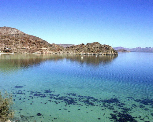
Conception Bay is the largest in Baja and is located just minutes south of Mulege.Dozens of beautiful sandy beaches can be found on the west coast. The gem of this region is a group of beaches right next to a large bay called Bahia Coyote and are a tropical paradise, with everything and deserted islands off the coast. Honey, I'm home!

The first beach that visitors see when going south on the main highway is the beach Santispac. This large bay within a bay provides space for camping on the beach in the short or long term, and restaurants behind the beach. This piece of paradise is filled with tourists in winter months because the colder latitudes people like to call this place home sweet home "while waiting for the frost and ice melt in their respective houses.

One of the beaches that can not be seen from the highway is Playa Arena. Here it is planning to build a pier, and land with ocean views as well as a hotel with a private beach. You can see many more homes as you walk away in a southerly direction on Coyote Bay

Description
The bay is considered by many as the most beautiful in the state. The contrast between its white beaches, the calm of its waters and the hardness of the surrounding mountains make a little paradise Conception Bay.

In the bay are different beaches, each with something different to offer. Santispac is flanked by mangroves and the portion of the surrounding mountains paintings stored in an area known as The Tordillo, three kilometers inside. Another famous beach is The Cheese, displaying a white rocky hill with high tide becomes an island. Also notable for its beauty the beaches Concepción, Los Cocos, El Burro, the Buenaventura and Playa Armenta.

The bay water is kept between 22 ° and 30 ° Celsius for all you can swim, water sports or lie down to rest and sunbathe.

Finally, the Highway runs along the bay offering an excellent view from any point.


Getting there
If you want to get to Bahia Concepcion road, we recommend you follow the following route.

To arrive at Conception Bay from Mexico City, will have to make several transfers, the first will be leaving Mexico City to Culiacan, where you will make a time of 17 hours and 50 minutes. From there you will have to move you to Guaymas traveling 7 hours and 30 minutes away. Arriving at Guaymas must take the ferry that takes you to Santa Rosalia, on arriving at the port must take a bus to take you to Mulege, which runs 62 kilometers in about 40 minutes.


Tijuana, thriving town on the northern border of Mexico,

Tijuana, thriving town on the northern border of Mexico, is located on the northwest tip of the Baja California Peninsula, 189 km west of Mexicali and 29 miles south of San Diego, California in the United States. Its climate is warm with an average temperature of 21 ° C.

City, a meeting place of modern art, culture and history, is home to countless artistic and gastronomic festivals that fill the streets of vitality, such as the International Dance Show, which brings together figures of dance, song and music .

To enjoy the adventure on the outskirts of the city are more populated areas of vegetation such as the Laguna Salada and Guadalupe Canyon where you can go camping. Sports enthusiasts and thrills will enjoy the unique facilities such as golf clubs Real del Mar Golf Resort and horse racing and greyhound racing are presented in the traditional and Agua Caliente Greyhound Racetrack. For relaxation, there is no choice but to accept the invitation to visit the formidable sophisticated facilities of its spas and enjoy the pleasant atmosphere.

To enjoy the night Tijuana offers a host of clubs, bars and restaurants where you can enjoy the taste exotic dishes like lobster Puerto Nuevo, accompanied by an exquisite wine from the region of Valle de Guadalupe.
ARCHAEOLOGY

On the outskirts of Tijuana, there are two archaeological sites of special interest because of the presence of paintings.

The Vallecito. It is located in Tecate, 72 miles east of Tijuana by the federal highway. 2. Here we see examples of cave paintings that represent human figures and animals, among which are rooted Man, The Devil and The Shark. Open Wednesday to Sunday from 8:00 am to 17:00 pm.

Macahuí. It is located 154 km east of Tijuana by the federal highway. 2. In this place, located in a desert area will see a series of drawings of geometric and anthropomorphic shapes, similar to the Nazca region of Peru.

Contemporary Architecture

In Tijuana you can see examples of modern architecture which also reveals the multifaceted aspect of this city.

Tijuana Cultural Center. It is located at Av. Paseo de los Héroes and Av. Francisco Javier Mina s / n, Zona Urbana Río. This is a set of institutions dedicated to promoting art and culture, has designed a vision system as a leading architectural, either because the buildings are so new, as the field of planetary use the Omnimax film format the latest technology to attract people

Arco / Monumental Clock. It is located at Av. Revolution s / n. This monument represents the gateway to Tijuana and is considered an architectural icon in avant-garde


Related topics founded, please extend your search.

Discover the Real México - Enjoy it.