matehuala
Matehuala is a city and municipality from the state of San Luis Potosi, Mexico, founded on July 10, 1550. Its name refers to the battle cry of the Indians guachichiles originating in the region, it is presumed that meant some kind of threat or warning: "Do not come!". Professor Angel Veral cerritence call it City of the Camelias.
Location
The municipality is located in the upstate, in the highlands, the county seat has the following coordinates: 100 ° 39 'west longitude and 23 º 39' north latitude, with a height of 1.570 meters above sea level Tues
Its boundaries are: north, Cedral to the east, Nuevo Leon, on the south, Villa de Guadalupe, on the west, Villa de Guadalupe and Villa de la Paz.
The town was founded by D. Cayetano Medellin on June 10, 1550. It refers to the Indian word "MA-TE-HUA-LLAL" was the rallying cry of the savage Indians of the region and meant not to come!. In the year 1778 given the category of Villa, and finally in the year 1826 is called as a municipality.
Located in the northern part of the state, take Highway 57 towards Saltillo, the capital 193 km and 391 km Potosi Monterrey. Third largest state population and number of inhabitants. Nestled in the heart of the highlands of San Luis, in the shadow of Cerro Fraile, is an important commercial and mining, founded in 1590. The name is derived from the words, "Mate-hua-call" which means "Do not come," battle cry of the Chichimecas against the Spanish.
In the seventeenth century, Spanish settlers had established a farm which they called Matehuala. With time and the interest that produced the discovery of the nearby veins of metal, went to live Guadalcazar residents, running the eighteenth century.
The findings minerals in the surrounding mountains rise to the height of the city as it was here works transportation of metals. In 1871 he was awarded the title of city Matehuala.
Trade and exploitation of minerals and fiber sisal are the main economic activities of the population.
The city has the seal of the old villages with narrow streets, majestic mansions, squares and parks, which give a nice look. The activity center of the city's tree-lined main square, surrounded by imposing buildings of the nineteenth century, such as Los Arcos and the Temple of San Salvador
Ver mapa más grande

Mexico tourism information, Travel by méxico.best tourist sites and more destinatios for adventurers. Hotels and hostels, ecotourism and extreme sports, All you need to know about tourism, art and culture in Mexico.
Showing posts with label san luis potosi. Show all posts
Showing posts with label san luis potosi. Show all posts

Santa María Acapulco is a community of Mexican state of San Luis Potosi, located in the Sierra Gorda
santa maria acapulco
Santa María Acapulco is a community of Mexican state of San Luis Potosi, located in the Sierra Gorda to the south of the state territory, is part of the municipality of Santa Catarina, its population is made up of indigenous peoples of the pame.
Santa Maria Acapulco is located in the southeastern area of San Luis Potosi, very close to the borders of the State of Queretaro, in the area of the Huasteca and the Sierra Gorda, its geographical coordinates of the location are 21 ° 28 ' 20? N 99 ° 26'29? O? /? 21.47222, -99.44139 at an altitude of 800 meters above sea level, its main road is a rural road that links to State Highway 8, San Luis Potosi through which it communicates with its municipal , Santa Catarina and Rayon and Lagunillas population in San Luis Potosi and the Arroyo Seco in Queretaro


Ver mapa más grande
Santa María Acapulco is a community of Mexican state of San Luis Potosi, located in the Sierra Gorda to the south of the state territory, is part of the municipality of Santa Catarina, its population is made up of indigenous peoples of the pame.
Santa Maria Acapulco is located in the southeastern area of San Luis Potosi, very close to the borders of the State of Queretaro, in the area of the Huasteca and the Sierra Gorda, its geographical coordinates of the location are 21 ° 28 ' 20? N 99 ° 26'29? O? /? 21.47222, -99.44139 at an altitude of 800 meters above sea level, its main road is a rural road that links to State Highway 8, San Luis Potosi through which it communicates with its municipal , Santa Catarina and Rayon and Lagunillas population in San Luis Potosi and the Arroyo Seco in Queretaro


Ver mapa más grande
sótano de las golondrinas, Cave of Swallows, San Luis Potosi
sotano de las golondrinas , san luis potosí
Cave of Swallows, San Luis Potosi
The Cave of Swallows is a natural gulf located in the town of Aquismón belonging to the Mexican state of San Luis Potosi 21 ° 35'59? N 99 ° 05'56? O? /? 21.59972,-99.09889Coordenadas: 21 ° 35'59? N 99 ° 05'56? O? /? 21.59972, -99.09889. In particular, it is a karstic cave formed by water erosion in a waterproof failure of a plain stone calizaque has the characteristic of having a well outside opening narrower than the bottom, giving it a generally conical. The depth of the chasm is about 376 meters.The top opening is at ground level and has a diameter close to 60 meters, while the background has a maximum aperture of 300 meters by 60 at its narrowest. This site also has the distinction of being a natural refuge for birds, and that contrary to what its name implies, they are not swallows. This apparent contradiction is that the species can be found in the Cave of Swallows, swifts are in fact (though not common swifts, Apus apus, as these are birds of the Old World), often confused with the realswallows. The cave is also possible to find a species of parrots (Aratinga holochlora), locally called Parrots of cave.
This site also has the distinction of being a natural refuge for birds, and that contrary to what its name implies, they are not swallows. This apparent contradiction is that the species can be found in the Cave of Swallows, swifts are in fact (though not common swifts, Apus apus, as these are birds of the Old World), often confused with the realswallows.
a karstic cave formed by water erosion in an impermeable fault in a limestone plateau, and has the characteristic of having a well outside opening narrower than the bottom, giving it a generally conical. The top opening is at ground level.


media luna.- san luis potosí
media luna san luis potosi
tourist site located in the municipality of Rio Verde San Luis Potosi, Mexico.Crescent's name is because the lake is shaped like a crescent. It is of great importance for tourism, archaeological and agricultural. Crescent is ideal swimming and diving, counting also has a large area for camping.
This place is considered the most important source of state from the standpoint of scientific, historical, and ecological tourism.
It is located in the ejido El Jabali, the municipality of Rio Verde, and is reached by Highway 70 San Luis, Ciudad Valles, covering 125 kilometers, starting from the state capital, and approximately 10 kilometers, starting from the municipality of Rio Green.
The Crescent Lake is a protected nature reserve where you can camp, scuba diving, mountain biking and observing the flora and fauna, among other activities.
As its name implies, is a half moon in the clear water that emanates from birth, is populated by a great diversity of wildlife, fish of different varieties of freshwater turtles and the odd duck diver.
The water temperature fluctuates between 27 and 30 degrees Celsius, and springs from six births of different depths, which keep the shape of an inverted volcano.
The depths of these births has a depth of 36 meters, combined with the visibility of the waters, makes the Media Luna, the perfect place to practice diving, even for those who want to learn or are being initiated
tourist site located in the municipality of Rio Verde San Luis Potosi, Mexico.Crescent's name is because the lake is shaped like a crescent. It is of great importance for tourism, archaeological and agricultural. Crescent is ideal swimming and diving, counting also has a large area for camping.
This place is considered the most important source of state from the standpoint of scientific, historical, and ecological tourism.
It is located in the ejido El Jabali, the municipality of Rio Verde, and is reached by Highway 70 San Luis, Ciudad Valles, covering 125 kilometers, starting from the state capital, and approximately 10 kilometers, starting from the municipality of Rio Green.
The Crescent Lake is a protected nature reserve where you can camp, scuba diving, mountain biking and observing the flora and fauna, among other activities.
As its name implies, is a half moon in the clear water that emanates from birth, is populated by a great diversity of wildlife, fish of different varieties of freshwater turtles and the odd duck diver.
The water temperature fluctuates between 27 and 30 degrees Celsius, and springs from six births of different depths, which keep the shape of an inverted volcano.
The depths of these births has a depth of 36 meters, combined with the visibility of the waters, makes the Media Luna, the perfect place to practice diving, even for those who want to learn or are being initiated
best of san luis potosí
San Luis Potosi
San Luis Potosi is one of 31 states that together make up the Federal District of Mexico's 32 states.
Located on the north-central region of the country and occupies a wide area of central Mexico. Its official name is Free and Sovereign State of San Luis Potosi and its land area of 63, 068 km is the fifteenth largest state in Mexico.
It is located between 24 ° 22 'and 21 ° 07' north latitude and 98 ° 20 'and 102 ° 17' west longitude. Bordered on the north Nuevo Leon in northeastern Tamaulipas, Veracruz to the east, southeast with Hidalgo, Queretaro and Guanajuato south, west and southwest of Zacatecas Jalisco.
Political division
The state of San Luis Potosi has 58 municipalities, which are distributed in four main geographical areas: Huasteca Region, Middle Region, Central Region and Potosi Altiplano.
Culture
In pre-Hispanic times, the territory of what is now the State of San Luis Potosi was cultural border of Arid Regions and Mesoamerica allowing a great diversity of peoples and customs.
Huasteca area was inhabited by Mesoamerican peoples, peoples who shared hundreds of years ago the same culture as the Maya and possibly separated from them in the Preclassic when the Zapotec and Olmec were increasing their presence to the center and south of what today Veracruz. The Huasteca left traces of their presence in the numerous archaeological sites that today are still in the states of Tamaulipas, Hidalgo, Veracruz and San Luis Potosi. In the Huasteca region two sites are under investigation: Tamtok and comfort, both located in the municipality of Tamuín. During the Epi was invaded by the Huasteca Nahuatl cultures. Today is present Teenek and Huasteca Nahuatl.
The middle of San Luis Potosi was a populated area in pre-Hispanic times, the cultures pame and Otomi. These cultures, as in all border-shared ways of life of both regions. That is, shared by both the agricultural and sedentary way as nomadic hunter. They currently live in the middle pame cultures who call themselves xi'oi
In the highlands of San Luis, in the territory known as the Great Tunal chichimeca culture was developed (Zacatecas, Copuces, guamares, jonaces, Huachichiles, etc).These Indians chichimeca developed different cultural patterns to the Mesoamerican (distinguished by their sedentary lifestyle and interest in building towns and theocratic centers) spread this way of life throughout North America. The chichimeca were skilled hunters and warriors. The Postclassic Nahua tried to dominate (as they had done for many Mesoamerican territories) chichimecas land, without success. Hence the cultural hatred towards chichimeca culture and the emergence of the first speeches that accuse it chichimeca as "savage", "uneducated", "pagan", "inhuman", including "Caribbean." The Spanish at the time of the conquest will repeat the same speech for 50 years by maintaining an unsuccessful war: the "War Chichimeca"
The state of San Luis Potosi is rich in culture, heritage and history. Pamela Tribe is divided into two regions - North Pame, which includes the towns of Alaquines, Cardenas, Ciudad del Maiz, parts of Rio Verde, Tamasopo, and El Naranjo. Pamela South - comprising the municipalities of Rayon, Lagunillas, Santa Catarina, and parts of Tamasopo. These indigenous tribes speak the language Pame, but certain palablas change between North and Pame Pame South.
The largest concentration of Northern Pame Tribe is in the municipality of Alaquines.Within this tribe born Marcelino Martínez de León, daughter of Mrs. Severiana Martinez (an indigenous tribe Pamela), and a Spanish that was devoted to trade-Corona De Leon surname. The young Marcelina Martinez De Leon came to make the Princess of the Tribe Northern Pame, however, during the Mexican Revolution, she and her mother were taken to safe places to avoid death. Then he joined in marriage to the Mexican Army captain Paulino First Salazar Ceballos, who was originally from La Libertad "Colonia Agricultural and Military" town of Ciudad del Maiz, SLP
History
The "Town of San Luis Mesquitique" was founded on November 3, 1592 at the site in 1583 Fray Diego de la Magdalena had gathered about Indian guachichiles, which arrived in the territory of San Luis in the thirteenth century.
The name of San Luis is in honor of San Luis Rey de France, later the Viceroy Francisco Fernandez de la Cueva Duke of Alburquerque conceded that the Pueblo and Mines of Potosi was constituted a city status on May 30, 1656. Mesquitique Renaming the Potosi, referring to the wealth of the mines of Cerro de San Pedro compared with the mines of Potosi in Bolivia.
Also approved the Viceroy Fernández de la Cueva coat of arms: "From a hill on a blue field and gold two silver and two bars of gold and the image of San Luis in the summit." In addition, the city was given authority "... to make ordinances for its government ...". King Philip IV of Spain's royal charter August 17, 1658 gives the appropriate approval.
* San Luis Potosí has made great contributions to the history of Mexico, including the Presidents of the Republic Miguel Barragán and Mariano Arista.
* After the U.S. invasion was proposed to rename the entity to "San Luis de la Patria" because of the great contributions that local government did the Mexican army.
* In 1863 the city of San Luis Potosi was declared capital of the country by President Benito Juárez.
* On November 12, 1853, the Mexican government held a contest to write the lyrics of a hymn to the homeland of many compositions presented, won first place, written by the poet of San Luis, Francisco González Bocanegra.
* In 1910, Francisco I. Madero promulgating the Plan de San Luis, starting the Mexican Revolution.
The climate of San Luis Potosi is dry. The last time it snowed was on December 12, 1997.
Demography
According to the first available census on ethnicity (1921), the state was formed by Indigenous 30.6%, 61.89% 7.51% Mestizo and White, these amounts have changed now considering a higher percentage mestizo.
Economy
San Luis Potosí has an advantageous location in the Mexican territory because it is a compromise between the three cities of the country: Mexico City, Monterrey and Guadalajara and from 4 major high ports: Tampico, Altamira, Manzanillo and Mazatlan . Besides its varied climates and allow it to be one of the few states where you can develop a significant business infrastructure.
The economic impact of state is due to several factors such as tourism, logistics industry and development that benefits producers and allows the rapid deployment of its products to almost anywhere in Mexico. However, this is just economic development in the state capital, which has caused a great migration to the suburbs to rural areas as well as other neighboring states such as Nuevo Leon and Tamaulipas, and mainly to the United States.
This state has been characterized in recent years for its highly developed (especially the capital city of San Luis Potosi), this is because the governors of the last six years have been able to worry about the growth of government giving himself to the task ofgrow the organization taking advantage of its geographical location. Today we have developed a large number of industrial parks that offer benefits to companies setting up in them, the policy applied to each park's arrival makes it attractive to industry.
Sites and attractions
Cave of Swallows
The Cave of Swallows is a natural gulf located in the town of Aquismón belonging to the Mexican state of San Luis Potosi. In particular, it is a karstic cave formed by water erosion in an impermeable fault in a limestone plateau, and has the characteristic of having a well outside opening narrower than the bottom, giving it a generally conical.The depth of the chasm is about 376 meters. The top opening is at ground level and has a diameter close to 60 meters, while the background has a maximum aperture of 300 meters by 60 at its narrowest. This site also has the distinction of being a natural refuge for birds, and that contrary to what its name implies, they are not swallows.This apparent contradiction is that the species can be found in the Cave of Swallows, swifts are in fact (though not common swifts, Apus apus, as these are birds of the Old World), often confused with the real swallows. The cave is also possible to find a species of parrots (Aratinga holochlora), locally called Parrots of cave.
Las Pozas Xilitla
Cascada de El Salto
La Cascada de El Salto is located in the municipality of El Naranjo, 171.5 km E-NE of the state capital of San Luis Potosi, Mexico (22.34 N 99.22 W).
Cascada de Minas Viejas
La Cascada de Minas Viejas is located in the municipality of El Naranjo, in the state of San Luis Potosi, Mexico (22.22 N, 99.17 W).
In the city of San Luis Potosi, take Highway 80 (Tampico-Barra de Navidad), 273 km to El Naranjo, once there is around 16 km on the road to the driving, take the deviation towards Maitínez and Minas Viejas .
These are two waterfalls, 50 m high, surrounded by lush vegetation, forming a pond.Here you can camp and swim and visit the neighborhood where other waterfalls are located and the Patos lagoon, where you can fish.
Tamil Waterfall
Tamil Waterfall is a waterfall in Mexico about 105 meters high, falls on the River Tampaón which changes its name after the fall of water at Gallinas River, all located west of Aquismón in the region known as the Huasteca. Access is by road from San Luis Potosi, later taking a path to Tanchachín ejido in which you take a boat to go to the waterfall. The last part of the journey to the waterfall you can not do boat, you need to do on foot.
There are 2 suburbs from which you can take a boat to go to the waterfall. The boat ride lasts longer than 1 hour, in what can be observed across the river landscape. It is possible to rappel from other activities.
Real de Catorce
Real de Catorce is a mining and tourist population within the state of San Luis Potosi, Mexico.
One of the major mining centers in San Luis Potosi Real de Minas de Nuestra Señora de la Limpia Concepcion de Guadalupe de los Alamos de Catorce, or better known as Real de Catorce, soon became one of the most important mining centers of the state . It is difficult to determine when it was discovered the first grain, but in 1772 was real or a mining town, it's up to August 11, 1777 when documents comes as the term of "fourteen".
Actually it was not until 1778 when they found the richest vein is well founded as the real, because in that year came a large number of miners in search of riches that the land offered. And that thought was not far from reality, as Real de Catorce was one of the richest mines of New Spain, in 1803 ranked second worldwide in the amount of silver produced.
Village life was spent in the midst of the feverish activity of the miners who tore into the bowels of the earth silver. When the mines stopped producing in the amount used, weak veins, we thought that the town would die and become a ghost town. However, something was not planned, kept alive the faith of the people, due mainly to the cult of San Francisco, whose seated statue is located in the sanctuary regularly target and nurtured thousands of fervent pilgrimages.
In 2001, Real de Catorce was included in the Magic Towns program of the Ministry of Tourism.
Cerro de San Pedro
The municipality is located in the center of the state. The coordinates of the municipal are: 100 º 48 'west longitude and 22 º 13' north latitude with a height of 2.040 mesnm.
Its boundaries are: north and west with Soledad de Graciano Sanchez, on the east Armadillo de los Infantes, on the south and San Luis Potosi Villa de Zaragoza.
In 1583, in the town of Mesquitique, Fray Diego de la Magdalena brought several Huachichiles natural. Among these was one called Cualiname or Gualiname, which called his attention to bringing in your face painting gold lines (embrijado, this mix was made with cinnabar, animal fat and traces of gold). The monk asked where he got that pigment. The natural made him understand that the east from its current location was a lot of that dust.
Fray Diego de la Magdalena reported his discovery to Fray Francisco Franco and this in turn tells the Captain Miguel Caldera, who took over the place.
Captain Miguel Caldera sent to prospect the place Gregorio de Leon, Juan de la Torre and Peter de Anda. The latter was named the place San Pedro del Potosí, in honor of the saint of his name and memory of the famous mines of Potosi in Upper Peru, now Bolivia (Potosi's name derives from the Quechua word, poc- to-si, which translates to immense wealth.)
On the hill and around found much gold and silver ore, but there was enough water to make profit. The closest water was to the north, a region still dominated by various tribes chichimecas in the area that later would settle the city of San Luis Potosi.
Historian Basalenque Primo Feliciano Velázquez and included lengthy descriptions of place in their relationships.
Crescent Lagoon
The Crescent Lake is a tourist site located in the municipality of Rio Verde San Luis Potosi, Mexico. Crescent's name is because the lake is shaped like a crescent. It is of great importance for tourism, archaeological and agricultural. Crescent is ideal swimming and diving, counting also has a large area for camping.
In the background you can see remains of two skeletons of mammoth and therefore outside the country is known as "Mammoth Lake", these remains (bones) has been preserved thanks to the lake is a volcanic crater and the water is sulphurous the average temperature is around 30 º C and is extremely crystalline, although the sediment is easily agitated. In Rio Verde there is also a good diving service.
Matehuala
Matehuala is a municipality from the state of San Luis Potosi, Mexico, founded on July 10, 1550. Its name refers to the battle cry of the Indians Huachichiles, originating in the region, it is presumed that meant some kind of threat or warning: "Do not come!". Professor Angel Veral cerritence call it The City of the Camelias.
In pre-Columbian times, Potosi Altiplano area was populated by indigenous Huachichiles guachichiles or that are known, were a nomadic people whose main economic activity was the collection, so it is characterized by being knowledgeable about herbs.
No wore dresses. Women fajaban the waist a deerskin. Painted their bodies with red ocher and other minerals, black and yellow, they got mine. Were shorn when they were in mourning. Did not bury their dead, but the burned and the ashes kept in a carrying Costalitos always. Fanning the ashes of their enemies.
In their prisoners they took away the hair, which hung on the back. Nerves used to tie them to their flint arrow and the bones of the taps to display as a trophy. Spared only boys and young women.
For the most part, their social organization was based on the nuclear family. They lived in small villages in the south and north, the prevailing tribal settlement is less stable. In general, the northern tribes were smaller than the south. Polygamy characterized the northern tribes and monogamy to the south, taking the wife more freedom than elsewhere. There was inter-tribal marriages as well intratribal
San Luis Potosi is one of 31 states that together make up the Federal District of Mexico's 32 states.
Located on the north-central region of the country and occupies a wide area of central Mexico. Its official name is Free and Sovereign State of San Luis Potosi and its land area of 63, 068 km is the fifteenth largest state in Mexico.
It is located between 24 ° 22 'and 21 ° 07' north latitude and 98 ° 20 'and 102 ° 17' west longitude. Bordered on the north Nuevo Leon in northeastern Tamaulipas, Veracruz to the east, southeast with Hidalgo, Queretaro and Guanajuato south, west and southwest of Zacatecas Jalisco.
Political division
The state of San Luis Potosi has 58 municipalities, which are distributed in four main geographical areas: Huasteca Region, Middle Region, Central Region and Potosi Altiplano.
Culture
In pre-Hispanic times, the territory of what is now the State of San Luis Potosi was cultural border of Arid Regions and Mesoamerica allowing a great diversity of peoples and customs.
Huasteca area was inhabited by Mesoamerican peoples, peoples who shared hundreds of years ago the same culture as the Maya and possibly separated from them in the Preclassic when the Zapotec and Olmec were increasing their presence to the center and south of what today Veracruz. The Huasteca left traces of their presence in the numerous archaeological sites that today are still in the states of Tamaulipas, Hidalgo, Veracruz and San Luis Potosi. In the Huasteca region two sites are under investigation: Tamtok and comfort, both located in the municipality of Tamuín. During the Epi was invaded by the Huasteca Nahuatl cultures. Today is present Teenek and Huasteca Nahuatl.
The middle of San Luis Potosi was a populated area in pre-Hispanic times, the cultures pame and Otomi. These cultures, as in all border-shared ways of life of both regions. That is, shared by both the agricultural and sedentary way as nomadic hunter. They currently live in the middle pame cultures who call themselves xi'oi
In the highlands of San Luis, in the territory known as the Great Tunal chichimeca culture was developed (Zacatecas, Copuces, guamares, jonaces, Huachichiles, etc).These Indians chichimeca developed different cultural patterns to the Mesoamerican (distinguished by their sedentary lifestyle and interest in building towns and theocratic centers) spread this way of life throughout North America. The chichimeca were skilled hunters and warriors. The Postclassic Nahua tried to dominate (as they had done for many Mesoamerican territories) chichimecas land, without success. Hence the cultural hatred towards chichimeca culture and the emergence of the first speeches that accuse it chichimeca as "savage", "uneducated", "pagan", "inhuman", including "Caribbean." The Spanish at the time of the conquest will repeat the same speech for 50 years by maintaining an unsuccessful war: the "War Chichimeca"
The state of San Luis Potosi is rich in culture, heritage and history. Pamela Tribe is divided into two regions - North Pame, which includes the towns of Alaquines, Cardenas, Ciudad del Maiz, parts of Rio Verde, Tamasopo, and El Naranjo. Pamela South - comprising the municipalities of Rayon, Lagunillas, Santa Catarina, and parts of Tamasopo. These indigenous tribes speak the language Pame, but certain palablas change between North and Pame Pame South.
The largest concentration of Northern Pame Tribe is in the municipality of Alaquines.Within this tribe born Marcelino Martínez de León, daughter of Mrs. Severiana Martinez (an indigenous tribe Pamela), and a Spanish that was devoted to trade-Corona De Leon surname. The young Marcelina Martinez De Leon came to make the Princess of the Tribe Northern Pame, however, during the Mexican Revolution, she and her mother were taken to safe places to avoid death. Then he joined in marriage to the Mexican Army captain Paulino First Salazar Ceballos, who was originally from La Libertad "Colonia Agricultural and Military" town of Ciudad del Maiz, SLP
History
The "Town of San Luis Mesquitique" was founded on November 3, 1592 at the site in 1583 Fray Diego de la Magdalena had gathered about Indian guachichiles, which arrived in the territory of San Luis in the thirteenth century.
The name of San Luis is in honor of San Luis Rey de France, later the Viceroy Francisco Fernandez de la Cueva Duke of Alburquerque conceded that the Pueblo and Mines of Potosi was constituted a city status on May 30, 1656. Mesquitique Renaming the Potosi, referring to the wealth of the mines of Cerro de San Pedro compared with the mines of Potosi in Bolivia.
Also approved the Viceroy Fernández de la Cueva coat of arms: "From a hill on a blue field and gold two silver and two bars of gold and the image of San Luis in the summit." In addition, the city was given authority "... to make ordinances for its government ...". King Philip IV of Spain's royal charter August 17, 1658 gives the appropriate approval.
* San Luis Potosí has made great contributions to the history of Mexico, including the Presidents of the Republic Miguel Barragán and Mariano Arista.
* After the U.S. invasion was proposed to rename the entity to "San Luis de la Patria" because of the great contributions that local government did the Mexican army.
* In 1863 the city of San Luis Potosi was declared capital of the country by President Benito Juárez.
* On November 12, 1853, the Mexican government held a contest to write the lyrics of a hymn to the homeland of many compositions presented, won first place, written by the poet of San Luis, Francisco González Bocanegra.
* In 1910, Francisco I. Madero promulgating the Plan de San Luis, starting the Mexican Revolution.
The climate of San Luis Potosi is dry. The last time it snowed was on December 12, 1997.
Demography
According to the first available census on ethnicity (1921), the state was formed by Indigenous 30.6%, 61.89% 7.51% Mestizo and White, these amounts have changed now considering a higher percentage mestizo.
Economy
San Luis Potosí has an advantageous location in the Mexican territory because it is a compromise between the three cities of the country: Mexico City, Monterrey and Guadalajara and from 4 major high ports: Tampico, Altamira, Manzanillo and Mazatlan . Besides its varied climates and allow it to be one of the few states where you can develop a significant business infrastructure.
The economic impact of state is due to several factors such as tourism, logistics industry and development that benefits producers and allows the rapid deployment of its products to almost anywhere in Mexico. However, this is just economic development in the state capital, which has caused a great migration to the suburbs to rural areas as well as other neighboring states such as Nuevo Leon and Tamaulipas, and mainly to the United States.
This state has been characterized in recent years for its highly developed (especially the capital city of San Luis Potosi), this is because the governors of the last six years have been able to worry about the growth of government giving himself to the task ofgrow the organization taking advantage of its geographical location. Today we have developed a large number of industrial parks that offer benefits to companies setting up in them, the policy applied to each park's arrival makes it attractive to industry.
Sites and attractions
Cave of Swallows
The Cave of Swallows is a natural gulf located in the town of Aquismón belonging to the Mexican state of San Luis Potosi. In particular, it is a karstic cave formed by water erosion in an impermeable fault in a limestone plateau, and has the characteristic of having a well outside opening narrower than the bottom, giving it a generally conical.The depth of the chasm is about 376 meters. The top opening is at ground level and has a diameter close to 60 meters, while the background has a maximum aperture of 300 meters by 60 at its narrowest. This site also has the distinction of being a natural refuge for birds, and that contrary to what its name implies, they are not swallows.This apparent contradiction is that the species can be found in the Cave of Swallows, swifts are in fact (though not common swifts, Apus apus, as these are birds of the Old World), often confused with the real swallows. The cave is also possible to find a species of parrots (Aratinga holochlora), locally called Parrots of cave.
Las Pozas Xilitla
Cascada de El Salto
La Cascada de El Salto is located in the municipality of El Naranjo, 171.5 km E-NE of the state capital of San Luis Potosi, Mexico (22.34 N 99.22 W).
Cascada de Minas Viejas
La Cascada de Minas Viejas is located in the municipality of El Naranjo, in the state of San Luis Potosi, Mexico (22.22 N, 99.17 W).
In the city of San Luis Potosi, take Highway 80 (Tampico-Barra de Navidad), 273 km to El Naranjo, once there is around 16 km on the road to the driving, take the deviation towards Maitínez and Minas Viejas .
These are two waterfalls, 50 m high, surrounded by lush vegetation, forming a pond.Here you can camp and swim and visit the neighborhood where other waterfalls are located and the Patos lagoon, where you can fish.
Tamil Waterfall
Tamil Waterfall is a waterfall in Mexico about 105 meters high, falls on the River Tampaón which changes its name after the fall of water at Gallinas River, all located west of Aquismón in the region known as the Huasteca. Access is by road from San Luis Potosi, later taking a path to Tanchachín ejido in which you take a boat to go to the waterfall. The last part of the journey to the waterfall you can not do boat, you need to do on foot.
There are 2 suburbs from which you can take a boat to go to the waterfall. The boat ride lasts longer than 1 hour, in what can be observed across the river landscape. It is possible to rappel from other activities.
Real de Catorce
Real de Catorce is a mining and tourist population within the state of San Luis Potosi, Mexico.
One of the major mining centers in San Luis Potosi Real de Minas de Nuestra Señora de la Limpia Concepcion de Guadalupe de los Alamos de Catorce, or better known as Real de Catorce, soon became one of the most important mining centers of the state . It is difficult to determine when it was discovered the first grain, but in 1772 was real or a mining town, it's up to August 11, 1777 when documents comes as the term of "fourteen".
Actually it was not until 1778 when they found the richest vein is well founded as the real, because in that year came a large number of miners in search of riches that the land offered. And that thought was not far from reality, as Real de Catorce was one of the richest mines of New Spain, in 1803 ranked second worldwide in the amount of silver produced.
Village life was spent in the midst of the feverish activity of the miners who tore into the bowels of the earth silver. When the mines stopped producing in the amount used, weak veins, we thought that the town would die and become a ghost town. However, something was not planned, kept alive the faith of the people, due mainly to the cult of San Francisco, whose seated statue is located in the sanctuary regularly target and nurtured thousands of fervent pilgrimages.
In 2001, Real de Catorce was included in the Magic Towns program of the Ministry of Tourism.
Cerro de San Pedro
The municipality is located in the center of the state. The coordinates of the municipal are: 100 º 48 'west longitude and 22 º 13' north latitude with a height of 2.040 mesnm.
Its boundaries are: north and west with Soledad de Graciano Sanchez, on the east Armadillo de los Infantes, on the south and San Luis Potosi Villa de Zaragoza.
In 1583, in the town of Mesquitique, Fray Diego de la Magdalena brought several Huachichiles natural. Among these was one called Cualiname or Gualiname, which called his attention to bringing in your face painting gold lines (embrijado, this mix was made with cinnabar, animal fat and traces of gold). The monk asked where he got that pigment. The natural made him understand that the east from its current location was a lot of that dust.
Fray Diego de la Magdalena reported his discovery to Fray Francisco Franco and this in turn tells the Captain Miguel Caldera, who took over the place.
Captain Miguel Caldera sent to prospect the place Gregorio de Leon, Juan de la Torre and Peter de Anda. The latter was named the place San Pedro del Potosí, in honor of the saint of his name and memory of the famous mines of Potosi in Upper Peru, now Bolivia (Potosi's name derives from the Quechua word, poc- to-si, which translates to immense wealth.)
On the hill and around found much gold and silver ore, but there was enough water to make profit. The closest water was to the north, a region still dominated by various tribes chichimecas in the area that later would settle the city of San Luis Potosi.
Historian Basalenque Primo Feliciano Velázquez and included lengthy descriptions of place in their relationships.
Crescent Lagoon
The Crescent Lake is a tourist site located in the municipality of Rio Verde San Luis Potosi, Mexico. Crescent's name is because the lake is shaped like a crescent. It is of great importance for tourism, archaeological and agricultural. Crescent is ideal swimming and diving, counting also has a large area for camping.
In the background you can see remains of two skeletons of mammoth and therefore outside the country is known as "Mammoth Lake", these remains (bones) has been preserved thanks to the lake is a volcanic crater and the water is sulphurous the average temperature is around 30 º C and is extremely crystalline, although the sediment is easily agitated. In Rio Verde there is also a good diving service.
Matehuala
Matehuala is a municipality from the state of San Luis Potosi, Mexico, founded on July 10, 1550. Its name refers to the battle cry of the Indians Huachichiles, originating in the region, it is presumed that meant some kind of threat or warning: "Do not come!". Professor Angel Veral cerritence call it The City of the Camelias.
In pre-Columbian times, Potosi Altiplano area was populated by indigenous Huachichiles guachichiles or that are known, were a nomadic people whose main economic activity was the collection, so it is characterized by being knowledgeable about herbs.
No wore dresses. Women fajaban the waist a deerskin. Painted their bodies with red ocher and other minerals, black and yellow, they got mine. Were shorn when they were in mourning. Did not bury their dead, but the burned and the ashes kept in a carrying Costalitos always. Fanning the ashes of their enemies.
In their prisoners they took away the hair, which hung on the back. Nerves used to tie them to their flint arrow and the bones of the taps to display as a trophy. Spared only boys and young women.
For the most part, their social organization was based on the nuclear family. They lived in small villages in the south and north, the prevailing tribal settlement is less stable. In general, the northern tribes were smaller than the south. Polygamy characterized the northern tribes and monogamy to the south, taking the wife more freedom than elsewhere. There was inter-tribal marriages as well intratribal
Huasteca San Luis Potosi is a mixed region where nature, culture and adventurein a spectacular
huasteca potosina
La Huasteca San Luis Potosi is a mixed region where nature, culture and adventurein a spectacular way and that is where we will live this exciting journey filled withadventure and adrenaline to rappel down the side of one of the largest and mostbeautiful waterfalls and making the journey exciting rafting canyon rapids of St. Mary.
POTOSINA HUASTECA
The State of San Luis Potosi offers a wide range of attractions for all tourists. Forthose who like adventure without doubt an excellent choice Huateca Zone is a distinctand ideal place to commune with nature and meeting places of unexpected beauty, inwhich the action knows no boundaries.
La Huasteca San Luis Potosi, one of the four zones that make up the state, is set amidst the Sierra Madre.
Unspoiled region is noted for its tropical vegetation, bathed by many rivers and lakes,has 20 municipalities and is considered by many the ideal place for ecotourism andadventure tourism.
estacion catorce,and wadley
If you want to do this wonderful journey with an experienced guide I suggest you Station Fourteen directly address and then depart to Real. Station may contact Mr. Cristino Rodriguez, who will provide accommodation, tours and meals for a symbolic amount of money indeed. And if not, can stay at the hotel "The Highlands" and the tour for yourself, the rising camionetitas Real $ 30.00 charge them up and another $ 30.00 per download. Also the food is very inexpensive, has few restaurants but is very rich.In October, as everyone now knows, the Lord is celebrated San Francisco de Asis in the Real. On average, 50% of pilgrims coming through the tunnel, the rest is done via the station. If you are around these days, you'll see people camping in the main square, the hotel is at its maximum quota and there are many visitors to Monterrey, San Luis and the United States who see their families. Additionally, the plaza is also full of candy sellers regional Mexican food, plastics, clothing and many other objects. I suggest it is a party known as very traditional and provides fun for young and old. In December, the cold characteristic of the region, the inns are everywhere
Fourteen local Station is located in the municipality of Catorce (in the State of San Luis Potosi). It has 1064 inhabitants. Fourteen station is 1820 meters above sea level.
The municipality is located in the upstate, in the Altiplano, the county seat has the following coordinates 100 ° 53 'west longitude and 23 º 41' north latitude with a height of 2.680 meters over sea level. Its boundaries are: north to Vanegas, Cedral the northeast, east town of La Paz, the southeast town of Guadalupe, on the south Charcas southwest Santo Domingo, on the west state of Zacatecas.


Fourteen local Station is located in the municipality of Catorce (in the State of San Luis Potosi). It has 1064 inhabitants. Fourteen station is 1820 meters above sea level.
The municipality is located in the upstate, in the Altiplano, the county seat has the following coordinates 100 ° 53 'west longitude and 23 º 41' north latitude with a height of 2.680 meters over sea level. Its boundaries are: north to Vanegas, Cedral the northeast, east town of La Paz, the southeast town of Guadalupe, on the south Charcas southwest Santo Domingo, on the west state of Zacatecas.
el quemado, san luis potosí
the village of Cerro Quemado is located in the Municipality of Xilitla (in
the State of San Luis Potosi). It has 36 inhabitants. Cerro Quemado is
900 meters high.
The road to the top is not so defined, follow the instinct
and the signals indicating hardiness. After a few turns bizarre
the road and looks into the distance. Holds a lot of walking. Already within
Wirikuta.
Still kicking, it seems that the way to lengthen, but you know that up
is your goal. So you still enjoying it. A sign with a thought
Huichol stops you, makes you think and reminds you that this is more than
a walk is a challenge, a ritual, a meeting with yourself.
The silence of the vast nature fills you, the sound of birds
you happy and you wind up oxygen.
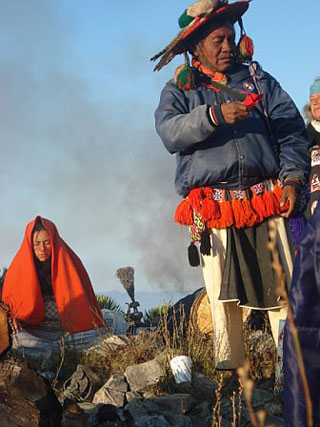
We reached the top. Three concentric circles made of stone
Mountain acclimate the place chosen by the Huichol. In the center is
offerings, candles, ribbons, tissue, water bottles, crafts
Huichol and ashes of the last and each ceremony is here
made over the years. Some are small ceremonial center
circles of stones with the ashes of fires, part of the ritual.
From up here I get to see everything to the four cardinal points. The
palms yucca, agaves and herbs beautify the landscape
with an intense shade of green.
In this place together many religions, or better yet, philosophies
life. There is a special energy. Above all, much peace. Will this
is it? To learn to live together in our differences and through its
respect, do live in peace?
Wirikuta is sacred, no doubt about it. For centuries they have come here
Huichol pilgrimage of those who have walked 80 km through
nature. It seems that they did or do three times a year, the first
effort is to ask, to say the second and the third for
thanks. In the ceremonial achieve their encounter with the gods,
purify his soul, pays tribute to Mother Earth, everything has its essence
the fertility of the land for their livelihood.
I do not know why they call the Cerro del Quemado if this place the soul
lights.
el quemado air view!!!


the State of San Luis Potosi). It has 36 inhabitants. Cerro Quemado is
900 meters high.
The road to the top is not so defined, follow the instinct
and the signals indicating hardiness. After a few turns bizarre
the road and looks into the distance. Holds a lot of walking. Already within
Wirikuta.
Still kicking, it seems that the way to lengthen, but you know that up
is your goal. So you still enjoying it. A sign with a thought
Huichol stops you, makes you think and reminds you that this is more than
a walk is a challenge, a ritual, a meeting with yourself.
The silence of the vast nature fills you, the sound of birds
you happy and you wind up oxygen.
We reached the top. Three concentric circles made of stone
Mountain acclimate the place chosen by the Huichol. In the center is
offerings, candles, ribbons, tissue, water bottles, crafts
Huichol and ashes of the last and each ceremony is here
made over the years. Some are small ceremonial center
circles of stones with the ashes of fires, part of the ritual.
From up here I get to see everything to the four cardinal points. The
palms yucca, agaves and herbs beautify the landscape
with an intense shade of green.
In this place together many religions, or better yet, philosophies
life. There is a special energy. Above all, much peace. Will this
is it? To learn to live together in our differences and through its
respect, do live in peace?
Wirikuta is sacred, no doubt about it. For centuries they have come here
Huichol pilgrimage of those who have walked 80 km through
nature. It seems that they did or do three times a year, the first
effort is to ask, to say the second and the third for
thanks. In the ceremonial achieve their encounter with the gods,
purify his soul, pays tribute to Mother Earth, everything has its essence
the fertility of the land for their livelihood.
I do not know why they call the Cerro del Quemado if this place the soul
lights.
el quemado air view!!!


The town of Real de Catorce, often abbreviated Real is located 260 km north of San Luis Potosi, Mexico
Estacion Catorce is located in the municipality of Catorce (in the State of San Luis Potosi). It has 1064 inhabitants. Fourteen station is 1820 meters above sea level.
The town of Real de Catorce, often abbreviated Real is located 260 km north of San Luis Potosi, Mexico, and currently has a full-time population of less than 1,000 inhabitants. This "ghost town" in the high and dry areas of northern San Luis Potosi, once established a thriving silver mining has long been a place of pilgrimage for Catholics and local Huichol shamans, and is now being discovered by international tourists drawn by the desert environment and renowned spiritual energy.
Among the main attractions in town include:
Bullring
Built in the nineteenth century pink stone, it is said that the acoustics of the place is remarkable, moreover, that since there is seen a magnificent view of the valley and the canyon surrounding the village.
Guadalupe Chapel
Its construction dates back to 1770 and presents a simple facade arch, flanked by towers of one body with almost no ornamentation. Its interior is a Latin cross and save an interesting set of expressive murals that reproduce various religious themes.
Palenque de Gallos
Built in pink stone and shaped like a Roman amphitheater was built in 1863 and it has been presented from cockfights to art shows when the city enjoyed its former glory. Currently, this site is used for activities and art and cultural events.
The Cathedral of the Immaculate Conception
Its construction began in the late eighteenth century, exactly in 1793, and concluded 24 years later, in 1817 neoclassical architectural style is Doric elements and presents a stark cover, made in stone. Its plant is in the form of a Latin cross, emphasizing the floor made of removable flooring mesquite wood.
Ogarrio Tunnel
It is the main entrance to the village, was opened in 1901 and says that its builder was a native of Ogarrio, Spain, Vicente Irizar. It has a length of 2.3 km in length. This was the last major construction was done in Real de Catorce, before its imminent decline. From here locate the area known as "Ghost Town" where are the ruins of the facilities of the mining company responsible for extracting silver.


The town of Real de Catorce, often abbreviated Real is located 260 km north of San Luis Potosi, Mexico, and currently has a full-time population of less than 1,000 inhabitants. This "ghost town" in the high and dry areas of northern San Luis Potosi, once established a thriving silver mining has long been a place of pilgrimage for Catholics and local Huichol shamans, and is now being discovered by international tourists drawn by the desert environment and renowned spiritual energy.
Among the main attractions in town include:
Bullring
Built in the nineteenth century pink stone, it is said that the acoustics of the place is remarkable, moreover, that since there is seen a magnificent view of the valley and the canyon surrounding the village.
Guadalupe Chapel
Its construction dates back to 1770 and presents a simple facade arch, flanked by towers of one body with almost no ornamentation. Its interior is a Latin cross and save an interesting set of expressive murals that reproduce various religious themes.
Palenque de Gallos
Built in pink stone and shaped like a Roman amphitheater was built in 1863 and it has been presented from cockfights to art shows when the city enjoyed its former glory. Currently, this site is used for activities and art and cultural events.
The Cathedral of the Immaculate Conception
Its construction began in the late eighteenth century, exactly in 1793, and concluded 24 years later, in 1817 neoclassical architectural style is Doric elements and presents a stark cover, made in stone. Its plant is in the form of a Latin cross, emphasizing the floor made of removable flooring mesquite wood.
Ogarrio Tunnel
It is the main entrance to the village, was opened in 1901 and says that its builder was a native of Ogarrio, Spain, Vicente Irizar. It has a length of 2.3 km in length. This was the last major construction was done in Real de Catorce, before its imminent decline. From here locate the area known as "Ghost Town" where are the ruins of the facilities of the mining company responsible for extracting silver.
<iframe width="400" height="350" frameborder="0" scrolling="no" marginheight="0" marginwidth="0" src="http://maps.google.com/maps?f=q&source=s_q&hl=es&geocode=&q=real+de+catorce&sll=37.0625,-95.677068&sspn=39.047881,79.013672&ie=UTF8&hq=Real+de+Catorce&hnear=Real+de+Catorce,+M%C3%A9xico&ll=23.689397,-100.885546&spn=0.706532,1.234589&t=h&z=10&iwloc=A&cid=8912400802861668125&output=embed"></iframe><br /><small><a href="http://maps.google.com/maps?f=q&source=embed&hl=es&geocode=&q=real+de+catorce&sll=37.0625,-95.677068&sspn=39.047881,79.013672&ie=UTF8&hq=Real+de+Catorce&hnear=Real+de+Catorce,+M%C3%A9xico&ll=23.689397,-100.885546&spn=0.706532,1.234589&t=h&z=10&iwloc=A&cid=8912400802861668125" style="color:#0000FF;text-align:left">Ver mapa más grande</a></small>


XILITLA: Surrealism become a garden; means "place of snails,
XILITLA: Surrealism become a garden; means "place of snails, is a coffee town located in the Sierra Madre Occidental mountain valley surrounded by.
A magical place of dreams that is located 350 km from Mexico City, founded by a group of Augustinian missionaries heading to the sixteenth century.
This place is surrounded by the most impressive waterfalls, high mountains and extensive vegetation that make this area a true paradise to admire the great variety of flora and fauna in the region.
After years of hiding this beautiful place, stopped an Englishman named Edward James who captivated by this place decided to buy several acres of an area known as Las Pozas, and later built around a garden of exotic orchids, but one day a frost Xilitla fell and ended up with plants giving way to the construction of a series of structures surreal figment of imagination of the English.
Within these buildings stand Gothic, and Egyptian, Edwar dreamlike features used during the construction of windows, corridors, stairs, doors, buildings, etc..
This set of concrete structures located between vegetation manage to make Xilitla Las Pozas in a stunning setting where visitors can imagine Edward like his many fantasies.
coffee is a village nestled in the Sierra Madre Oriental in the higher parts of the Huasteca, due to its location is also harvested coffee beans are also grown citrus.
Among the most interesting attractions Xilitla are: the surreal garden of Edward James, the waterfall The Comales, the Saltpeter Cave, the former convent of the Augustinians (now restored) and James Edward Museum located next to what was the house Plutarco Gastelum in the town itself which became an inn called The Castle. This museum has many personal items as well as photographs of James this character.
Xilitla word comes from Nahuatl and means "place of snails and the highest geographical point is" The Saddle "as a hill shaped like a saddle.
In this picturesque village in the middle of last century an English name Edward James started the construction of your dreams on this site: a surrealist garden in the middle of the forest vegetation of Xilitla.
To visit the garden surrealist recommend hiring the services of a guide for tourists who can explain the structures that cross the site as well as the history of its creator as this concrete maze contains unique stories.
From Ciudad Valles is organizing guided tours to this appeal and on the same day you visit the Cellar of the buses to see the spectacle of the swallows coming into this deep abyss.
A magical place of dreams that is located 350 km from Mexico City, founded by a group of Augustinian missionaries heading to the sixteenth century.
This place is surrounded by the most impressive waterfalls, high mountains and extensive vegetation that make this area a true paradise to admire the great variety of flora and fauna in the region.
After years of hiding this beautiful place, stopped an Englishman named Edward James who captivated by this place decided to buy several acres of an area known as Las Pozas, and later built around a garden of exotic orchids, but one day a frost Xilitla fell and ended up with plants giving way to the construction of a series of structures surreal figment of imagination of the English.
Within these buildings stand Gothic, and Egyptian, Edwar dreamlike features used during the construction of windows, corridors, stairs, doors, buildings, etc..
This set of concrete structures located between vegetation manage to make Xilitla Las Pozas in a stunning setting where visitors can imagine Edward like his many fantasies.
coffee is a village nestled in the Sierra Madre Oriental in the higher parts of the Huasteca, due to its location is also harvested coffee beans are also grown citrus.
Among the most interesting attractions Xilitla are: the surreal garden of Edward James, the waterfall The Comales, the Saltpeter Cave, the former convent of the Augustinians (now restored) and James Edward Museum located next to what was the house Plutarco Gastelum in the town itself which became an inn called The Castle. This museum has many personal items as well as photographs of James this character.
Xilitla word comes from Nahuatl and means "place of snails and the highest geographical point is" The Saddle "as a hill shaped like a saddle.
In this picturesque village in the middle of last century an English name Edward James started the construction of your dreams on this site: a surrealist garden in the middle of the forest vegetation of Xilitla.
To visit the garden surrealist recommend hiring the services of a guide for tourists who can explain the structures that cross the site as well as the history of its creator as this concrete maze contains unique stories.
From Ciudad Valles is organizing guided tours to this appeal and on the same day you visit the Cellar of the buses to see the spectacle of the swallows coming into this deep abyss.
Subscribe to:
Posts (Atom)