
Its name is derived from the roots Nahuas "or Tulare Tule" and Tzintle, which means "In the tule tular or behind."
It lies roughly between 2200 and 2400 meters above sea level and geographically located in the following coordinates: latitude 20 ° 04 '53''west longitude 98 ° 22' 07 'meridian of Greenwich.
It borders the following municipalities in the north with the municipality of Metepec, east and Cuautepec Acaxochitlan and west Acatlán and Singuilucan.
It is 93 miles from Mexico, D.F. (Pyramids and a short way away from Pachuca, the state capital of 46 km).
Tulancingo de Bravo, located 90 km from Mexico City is the second largest town in the state of Hidalgo.
The climate is temperate Tulancingo Bravo - cold, so the flora of this township has a vegetation consisting of pine, pine, fir, cedar, walnut and stick vulture.
This region is the telecommunications satellite earth stations, which was required to broadcast across the world the 1968 Olympics held in Mexico. They were the first Olympic Games broadcast via satellite.
The existence of Tulancingo valley dates back to the Cretaceous Period, 150 million years ago. However, the heart of the city has solidified lava flows that come from later periods and which give rise to systems such as volcanic rock volcanic sand. Just north of the valley is from the Jurassic period in the foothills of the Sierra Otomi Tepehua, specifically in the town of Acaxochitlan. To the south, twenty miles away, there are remnants of the neo-volcanic system, dating back 60 million years, which gives rise to the volcanoes Popocatepetl and Ixtaccihuatl.
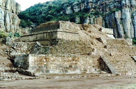
Tulantepec In Santiago, a town south of Tulancingo is Mammoth remains have been found, dating back to 6000 years old. Huapalcalco archaeological zone, pyramid s. VI.


Ver mapa más grande
No comments:
Post a Comment