+ 2,000 destinations find now !

Showing posts with label puebla. Show all posts

cantona, located in the state of Puebla

cantona, puebla


Cantona means House of the Sun, although this interpretation is doubtful, 1 is an important archaeological site located in the state of Puebla, eastern Mexico, near the border with Veracruz.

It was one of the cities with the highest degree of urbanization in pre-Hispanic times, probably founded by Olmeca-Xicalanca groups towards the end of the Late Preclassic period. The time of its peak corresponds to the Mesoamerica Epiclassic period, ie the period when Teotihuacan was no longer the main center of power in the region and small regional states vied for control of the various trade routes. Cantona was one of these regional centers, and control the resources of the Sierra Madre Oriental.

There has been little archaeological work and research on-site rescue and probably can only see about 10% of the site, maybe less. (There are views that only 1% has been rescatado.2

It was a fortified city with a high degree of urbanization in pre-Hispanic times, probably founded by Olmeca-Xicalanca groups towards the end of the Late Classic period


Henri de Saussure claims to have discovered Cantona in 1855 after a long, long search. Cantona is derived from the Nahuatl word Caltonal which means "house of the sun."

Located between the towns of Tepeyahualco and Coyoacan


site covers about 12 square kilometers for the study was divided into three broad units and worked the southern part, which is the best preserved, it is the Acropolis (the area where are located the main structures that gave shelter to the powerspolitical, economic and religious), being therefore a good indication of settlement.

According to the work, Cantona would be located chronologically between 600 and 1000 AD, its best coincides with the fall of the main cities of the Classic period (even thought it had something to do with the collapse of Teotihuacan to obstruct passage of goods from the coast to the highlands) and the arrival of warlike peoples who soon took over and dominated the field in our country


Zacapoaxtla, a town of 8062 inhabitants, capital of the homonymous municipality of Puebla (Mexico).

zacapoaxtla, puebla

The Municipality of Zacapoaxtla is located in the northern part of the State of Puebla its geographical coordinates are parallel 19 º 44'18 "and 19 º 59'18" north latitude and the meridian 97 ° 31'42 "97 ° 37'54 and" of West longitude.


Zacapoaxtla, a town of 8062 inhabitants, capital of the homonymous municipality of Puebla (Mexico). 

Located 172 km from the city of Puebla. The Municipality of Zacapoaxtla is located in the northern part of the state of Puebla, whose coordinates are the parallels 19 º 44'18 "and 19 º 59'18" north latitude and the meridians 97 ° 31'42 "97 ° 37'54 and" west longitude. The city is located at coordinates 19 ° 51'N 97 ° 36'W and. The name means Place of the municipality where it counts the grass, and comes from the Nahuatl roots: grass - grass; pohuat - have, and tla - place. This name comes from the tribute they had to pay the people, in this case rolls of grass. The municipality has 49,242 inhabitants (2000).


In the central region, close to the city of Zacapoaxtla advanced ethnic groups were established Nahua Chichimecas and Toltecs. Finally the Triple Alliance "Huey tlatocayotl" (Mexico-Texcoco-Tlacopan) subjected, leaving the manor in the hands of Texcoco. Established in the manors of San Juan de los Llanos (now free), as well as the Nauzontla, it was dangerous to the crossing between the two villages, prompting some families to form a hamlet between these domains, then, other families are taking up residence forming Tlatlauqui well as a settlement which was within the realm of Calzín Diego, requiring tribute which was paid in rolls of hay, a motif that originated the term Zacapohatlán.

Later, by feats of arms for the emancipation of Mexico, won the category of village on March 11, 1826. Repealing October 12, 1833, stands at the head of the party on 1 April 1835. In 1864, as governor and military commander of the state of Puebla, General Fernando Maria Ortega, told the town of Zacapoaxtla "The city's April 25" taking into account the glorious feats of arms in 1862 at the Battle of May 5 the forts of Loreto and Guadalupe, and in 1863 the participation of the brave Zacapoaxtlas in the convent of Santa Inés in the city of Puebla, (April 25) against the French.

Main attractions
Among the most outstanding monuments are the Municipal Palace, is remarkable in its architectural style ham.
Virgen de Guadalupe Temple of colonial, religious, Lord of Esquipulas Chapel of colonial, religious. Located at the north end of the court of the parish laterense and was built in 1803.
The parish of St. Peter the Apostle is located in the municipal dating from the sixteenth century, Constitution Square with landscaped areas and trees, iron benches and walkways. The obelisk stands at the center, alluding to the heroes of Zacapoaxtla. Community has a museum called Xolalpalcalli, people's house.
Among its natural beauty is the Cascada de la Gloria is located on the river Apulco, his fall is a large pond where the water takes on shades of transparent green, the waterfalls are also wedding veil and the pot


Huejotzingo is a municipality in the state of Puebla

huejotzingo, puebla

Huejotzingo is a municipality in the state of Puebla, located near the foothills of the Sierra Nevada. Has an area of ​​188.80 square kilometers, ranking it 67 withrespect to the other municipalities in the state. Its name in Nahuatl means SaucesSmall Sauzalito or small.


Ver mapa más grande

Tehuacan is located in southeastern Puebla state

tehuacan, puebla


Tehuacan is located in southeastern Puebla state, bordering the north TepancoLopez, Santiago Miahuatlan, Nicolás Bravo, and Vicente Guerrero, eastVicente Guerrero, San Antonio and Ajalpan Canada, south to San GabrielChilac, Zapotitlán and Altepexi and west Zapotitlán, San Martín Atexcal, John N.Tepanco Lopez Mendez.


The predominant climate in the Valley of Tehuacan, semi-dry is warm with little rain in summer.

The average annual temperature is 20 ° C.

Tehuacan is located in southeastern Puebla state, bordering the north TepancoLopez, Santiago Miahuatlan, Nicolás Bravo, and Vicente Guerrero, eastVicente Guerrero, San Antonio and Ajalpan Canada, south to San GabrielChilac, Zapotitlán and Altepexi and west Zapotitlán, San Martín Atexcal, John N.Tepanco Lopez Mendez.


Tehuacán (Nahuatl "theo" = God, "hua" = possessive, "can" = place, meaning "place of the gods") is a city, municipality and municipal seat located in the southeastern Mexican state of Puebla, located 130 km from the city of Puebla, 257 km from Mexico City and 321 km from the city of Oaxaca, at an altitude of1676 meters, semi-warm and semi-dry climate. The population according to2010 census, is 274.907 inhabitants.

Tehuacan has the distinction of being the place where they found the remains of the earliest domestication of maize (up to 5.000 years BC). In addition to thetown hall, the temple of Carmen and the Temple of San Francisco, Tehuacánmineralogical museum has the largest in Latin America.

Archaeological finds show that it was inhabited by village communities 8500 years before Christ. He had a major role in the process of domestication and cultivation of plants. In Tehuacán found the oldest fossil of corn in the world.(Museo del Valle de Tehuacán)


Ver mapa más grande

santa maria tonantzintla

santa maria tonantzintla


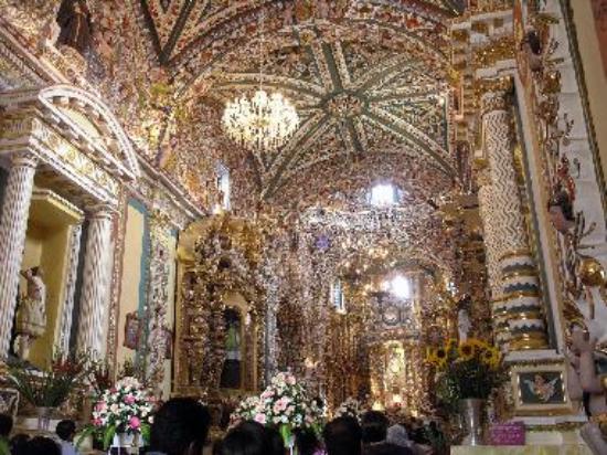
village in the municipality of San Andrés Cholula, home to the beautiful church ofSanta Maria Tonanzintla: "Place of our dear mother. "

During pre-Hispanic times there was a shrine dedicated to our dear motherTonantzin, Goddess of fertility, even that was replaced by the Christian church today.The construction of the temple covers sixteenth to the nineteenth century

Tonantzin In Mexican culture was a goddess identified with the Earth. Tonantzintlaword comes from Nahuatl and means place of our dear mother. With the arrival of the Spanish was added to the name of Santa Maria in honor of the Virgin Mary.

is located in the municipality of San Andrés Cholula (in the State of Puebla). It has122 inhabitants. Tonantzintla (Santa Maria Tonantzintla) is 2080 meters above sea level.

In this population can be reached from Cholula, or directly from Puebla, in which case the tour is 15 kilometers, the federal highway to Atlixco. Santa Maria Tonantzintla isthe cabinet that holds one of the richest jewels of Mexican baroque, exuberant in their degree: the Church of the Immaculate Conception of the Virgin Mary. What hit itsubjugates are polychrome interior plasterwork ornamentation.

Festivals & Fairs

Cheese Fair: is for the benefit of the cheese and is in honor of the Virgin of theConception is an exhibition and sale of cheese in the main square of this community,this is carried out in August.

Fair of the Assumption: August 15.

Easter: at this time the celebration is unique and special, because the church is transformed into a paradise, decorated with flowers and paper decorations.

Fair of the Immaculate Conception on 8 December


Zacatlan de las manzanas , puebla

Zacatlan de las manzanas , puebla

earthly paradise "where the symbol of sin is pleasure" enjoyment of their traditions, architecture, food, landscapes, drink and hospitality in its hotels and bungalows. Its name comes from the Nahuatl "zacatl" means straw or grass and "TLAN" place, so that together is: "place where the grass is plentiful." Also known as "Zacatlán de las manzanas ", is located in the northeastern part of the state, in the Sierra Norte de Puebla.Its average altitude is 2,150 meters above sea level, has a humid sub temperate climate that characterizes its unique natural beauty. 

Located at an altitude of 2,010 m on the northeast slope of the Sierra Madre Oriental, on the Left Bank Laxaxalpa. It borders the municipalities of Chignahuapan, Aquixtla, Tetela de Ocampo, Cuautempan, Tepetzintla, Ahuacatlán, Chiconcuautla, Ahuazotepec and Huauchinango. The climate is temperate humid with rain throughout the year. 

Zacatlán is located 131 kilometers from the city of Puebla. Its location allows it to be an important access between the state capital and the municipalities located in the Sierra Norte and as a link with the states of Tlaxcala and Hidalgo.

The municipality Zacatlán, is characterized as a local concentrator and distributor of services. Its territory amounts to 512.32 square kilometers, which places him in seventh place with respect to the other municipalities of the state, he live 62.788 inhabitants, of which 26.109 live in the municipal and 36.679 in the rest of the municipality.


Ver mapa más grande

iztaccihuátl

Iztaccihuatl

first record of environmental protection of this region is given in 1933 to be declared as forest protection zone land situated on the slopes and plains as part of the Great Basin of Mexico.

Altitude 5230 m / nm
Location f 19 ° 10 '39.6 "-? 98 ° 38 '29.1 "(top)
32 registered archaeological sites
Mexico and Puebla Entity
Decree on November 8. 1935, National Park
25679 hectares surface Popocatepetl
is the third largest mountain in Mexico after Pico de Orizaba (5.610 m) y Popocatepetl (5.452 m). Comes from the Nahuatl word "Iztac" which means white / ay "Cihuatl, woman.

volcano teyotl

teyotl
teyotl volcano
is the oldest part of the Iztaccihuatl, making it a highly eroded summit. Has severalclimbing routes, all very simple and seldom require specialized equipment. The summit of the volcano reaches 4.660 m. The name means "Where the stones are born", which immediately gives an idea of the geological importance of this place.

popocatépetl, volcano

Popocatepetl (Nahuatl: Popoca, tepetl "who smokes, mountain or mountain""mountain that smokes')? is an active volcano located in central Mexico, within the territorial limits of the states of Morelos, Puebla and Mexico. It is located about 55 kmsoutheast of Mexico City.

Popocatepetl volcano is a symmetrical cone-shaped, is attached to the north with theIztaccíhuatl through a mountain pass known as Paso de Cortes. The perennial icevolcano is near the mouth of the cone at the tip of the mountain. It is the secondhighest volcano in Mexico, with a maximum height of 5500 meters above sea level,only after the Pico de Orizaba to 5610 meters.
is an active volcano, and 5426 m (17,802 feet), the second highest peak in Mexico after the Pico de Orizaba (5.636 m/18, 491 ft). Popocatepetl volcano is linked to thenorth Iztaccíhuatl high chair known as the Paso de Cortés, and lies in the eastern half of the Trans-Mexican volcanic belt


Live
http://www.cenapred.unam.mx/popo/UltimaImagenVolcanI.html


en vivo
http://www.cenapred.unam.mx/popo/UltimaImagenVolcanI.html

tochimilco , It is located in the central state of Puebla,

It is located in the central state of Puebla, has a temperate-humid with summer rains.It is reached by the federal highway 150. "

Town founded by groups Olmec and Nahuatl. Cortes defeated in 1520 and in 1524 the parcel was given to Christopher Pacheco. For 824 became part of the state of Puebla. In 1895 he was a free municipality.


In the municipal seat of Tochimilco there is a very beautiful Temple and a former Franciscan convent of the Assumption of Our Lady was founded by Fray Diego de Olarte and built in 1560.


Tochimilco is located about 38 kilometers east of the capital of the state (Puebla), is 30 minutes drive as the first leg taking the toll road and 45 if the first way is taken as the federal highway. You have to cross the town of Atlixco, after San Pedro Ocoyucan and has arrived.

The altitude of 2,060 above sea level and the location is a transition from the temperate climates of the Valley of Atlixco, the cold of the highlands of the Sierra Nevada, this makes the average temperature ranges between 12 and 18 ° C .

Its people are quiet, despite having hosted and scene of several conflicts that have been part of larger context and historical landmarks such as the conquest of Mexico and its revolution, a century apart each.

The cultural and tourist attractions, are inherited from history that the people have. Is the Temple and a former Franciscan convent of the Assumption of Our Lady, the aqueduct "Los Arcos" and nursery located at the entrance to town on the road.


Access roads
Carretera Fed. or Highway 190 (via Atlixcayotl) to pass Atlixco, continuing signs of a secondary road.


Popocatepetl (Nahuatl: Popoca, tepetl "who smokes, mountain or mountain"

Popocatepetl (Nahuatl: Popoca, tepetl "who smokes, mountain or mountain" "mountain that smokes')? is an active volcano located in central Mexico, within the territorial limits of the states of Morelos, Puebla and Mexico. It is located about 55 km southeast of Mexico City [3].
Popocatepetl volcano is a symmetrical cone-shaped, is attached to the north with the Iztaccíhuatl through a mountain pass known as Paso de Cortes. The perennial ice volcano is near the mouth of the cone at the tip of the mountain. It is the second highest volcano in Mexico, with a maximum height of 5500 meters above sea level, only after the Pico de Orizaba to 5610 meters

Date of eruption Has had at least four explosive eruptions that collapsed cone with huge prehistoric landslide of gigantic proportions. 14.000 years ago there was a major eruption that produced heavy rain of ash and pumice. Over the next 12 millennia have happened, at least six large explosive eruptions. Its last major eruption occurred approximately between 800 and 1000 AD. (The accuracy of this date comes from a Remensa Telleriano Codex glyph, which represents the Popocatépetl like a big "boom" vertical ash reaching the stars. Contrast that with other Codex glyph Quauhtinchan, showing the volcano in quiet stage with a tiny "feather")


This image is updated every minute, shows the north flank of the volcano, including the glacier. Intense cloudy or transmission problems can sometimes prevent the visibility of the volcano
http://www.cenapred.unam.mx/popo/UltimaImagenVolcanI.html
Popocatepetl has perennial glaciers near the mouth of the cone. It is the second highest volcano in Mexico, with a height of 5.452 meters above sea level, second only to Citlaltépetl or Pico de Orizaba, with 5.610 meters.


Atlixco, Puebla

ATLIXCO
Atlixco is a town located southwest of the city of Puebla de Zaragoza, capital of the Mexican state of Puebla. He is known for its good climate and great floristic activity,trade and tourism which earned him being called Atlixco de las Flores, the best climatein the world, and Barn New Spain during the colonial era. The last Sunday ofSeptember, Atlixco is hosting a festival that brings together representatives of elevencultural regions of the state of Puebla, a festival that is called Huey Atlixcayotl or"Fiesta Grande de Atlixco" and that cultural heritage status of Puebla. The municipal seat is the heroic city of Atlixco De Mujica and Osorio, third largest city by population inthe state, after Capital and Tehuacan Puebla and the fourth largest city after Puebla deZaragoza, Tehuacan and Texmelucan respectively.


acatepec, church, puebla

Acatepec, PUEBLA

Situada a 13 Kilómetros de la Ciudad de Puebla Por la carretera federal, un
Atlixco, ya 20 Por la recta a Cholula, this Pequeña Población POSEE
also Una soberbia iglesia de Estilo barroco mexicano, Cuyo Decorado sí
realizó Entre 1650 y 1750, Cuando la talavera y poblanos El barroco
Su apogeo vivieron alcalde.

La fachada de Este Templo sí Halla Labrada y policromada de tal forma,
Semejá Que retablo de las Naciones Unidas. Consta de dos Cuerpos remate, y orlado de las Naciones Unidas
volutas, Con flameros Que se repiten en la espadaña y en la torre, Dando
Impresión de la fina repostería. El barroco en sí definen en Las Columnas
salomónicas de la torre, y El churrigueresco sí perfila en Las estípites
del Segundo Cuerpo y El Remate. Pero he aquí Más admirable of this Su Obra es
Vestido multicolor de mosaicos de talavera, FABRICADOS párrafo expresamente
Ella. Razón de Sobra tuvo ASI don Manuel Toussaint, CUANDO DIJO Que «la
magnificencia de la fachada es tal, parece Que sin Templo de porcelana
Digno de Ser Guardado Bajo capelo de cristal de las Naciones Unidas.


Ver mapa más grande

cholula puebla, site archeologic and city

Cholula is located 15 km west of the city of Puebla and its name comes from the Nahuatl roots "choloa" and "level" may mean "water leaking" or "place to escape."

The city is located in the central-eastern state of Puebla and is part of Valle de Cholula, at an altitude of 2.220 meters above sea level and covers an area of 51.03 square kilometers. The town is bordered on the north by the municipalities of John C.Bonilla, Cuautlancingo Coronango and south with the municipalities of San Gregorio and San Andrés Cholula Atzompa, east to the city of Puebla and west by the municipalities of San Jerónimo and Calpan Tecuanipan.


The main architectural monuments are located in this county are: The Great Pyramid of Quetzalcoatl, the Shrine of Our Lady of Remedies - a church built on a pyramid, where the Royal Chapel was built in 1540 based on drawings of the MosquitoCórdoba and has 49 domes and seven ships. Other monuments are crucial: The Convent of San Gabriel - a Franciscan foundation dating from 1540 and has a nave with Gothic figures, the Parish of San Pedro dates back to the seventeenth century, the Portal Guerrero of 44 arches and 170 meters long, the House of Culture and the University of the Americas.

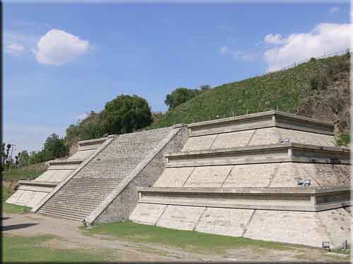
The Great Pyramid
It is considered the world's largest in total volume is 62 meters high consisting of adobe bricks for the base measures approximately 400 meters base. By hand, is considered the world's largest volume. have discovered several overlapping construction and different types of architectures and styles to highlight the Olmec and Teotihuacan.

Archaeological Site
In 1931 the architect Ignacio Marquina start your exploration by tunnels, and substructures that showed the historical periods - Archaeological large building.Which reached a length of 8 km, after 25 years of excavations, the tunnels were drawn from north to south and from east to west, following the contour of the different bases, slope of the slopes and stairs.

Building A is the oldest structure that contains the Great Pyramid, was built around 200 - 400 BC, is distinguished by its fill of adobe.

Building B is characterized by the fresco decoration of their boards.

Building C, which has a volume, even at the Pyramid of the Moon at Teotihuacan, is characterized by being completely staggered by the 4 sides.


Holidays during the year are: on 1 January celebrating the new year beginning, January 6, remembering the visit of the Magi to the baby Jesus, in the month of February, Shrove Tuesday is celebrated with the ancient Huehues (which means "old men") men and boys with masks and costumes dancing troupes organized, on 21 March in the archeological zone, is presented to the public and meet pre-Hispanic dance groups dressed in white to receive the spring in Holy Week staged the three falls, visiting the seven houses and to conclude the week, listening, Gloria Mass is held in the church of San Gabriel or the Convent as she is known around the town , during the month of June is the day of the Blessed or the fair girl. In the month of September from day 1 to 8 large fair is held even though most of the time is extended until 15 September, during this period are held dances, agricultural exhibitions, industry and tourism, in the month November is reminiscent of the departed, the feast that has existed since pre-Hispanic times, and inns in the season from 16 December to 25 in the main churches in the center of town praying and singing every day innunder the sponsorship of families who keep the tradition


Atlixco, Puebla

Atlixco is a town located southwest of the city of Puebla de Zaragoza, capital of the Mexican state of Puebla. He is known for its good climate and great floristic activity, trade and tourism which earned him being called Atlixco de las Flores, the best climate in the world, and Barn New Spain during the colonial era. The last Sunday of September, Atlixco is hosting a festival that brings together representatives of eleven cultural regions of the state of Puebla, a festival that is called Huey Atlixcayotl or "Fiesta Grande de Atlixco" and that cultural heritage status of Puebla. The municipal seat is the heroic city of Atlixco De Mujica and Osorio, third largest city by population in the state, after Capital and Tehuacan Puebla and the fourth largest city after Puebla de Zaragoza, Tehuacan and Texmelucan respectively.


Atlixco is located 40 km from the city of Puebla, on highway No.. 190. It is a pleasure to walk its streets punctuated by mellow buildings, like the house of the hearing, the mill of San Mateo, the Aqueduct of Los Arcos and the building Rascon. Here the seventeenth century left his glory in the churches of La Merced, San Augustine, and in the chapel of the Third Order.


HISTORY

In pre-Hispanic times Cuauhquechollán was known as "Eagle flight" after Acapetlahuacan "Place of reed mats" and then Atlixco. The first inhabitants of the Valley of Atlixco were Teochichimecas. It was also Xicalancas settlement and was subjected to the great Tenochtitlán.

Its geographical position made it the scene of fighting between the various ethnic groups who were seated nearby. The towns of Calpe, Huejotzingo and Cholula were played at various times the possession of the valley in the Spanish arrived was under the command of Huejotzingo. Pedro del Castillo and Christopher Ruiz de Cabrera founded the Villa de Carrion, Atlixco today, the September 22, 1579. In 1632 she was appointed head, regardless of Huejotzingo with eleven people in charge.

On March 3, 1706 becomes a kind of dominion, granted by King Philip V to Don José Sarmiento de Valladares granting him the title of the first Duke and Lord of Atlixco.Due to the events that were raised in the Independence, General Nicolás Bravo, Deputy President of the Republic, gave the title Atlixco City on 14 February 1843.


On October 19, 1847 the battalion Free Atlixco in front of General Joaquin Rea facing the American intervention that had occupied a month before getting beat in the Mexican capital.

E May 4, 1862 during the Second French Intervention in Mexico, the Hacienda de la Trapera atlixquenses and elements of the Mexican army of the republic, under the command of General Antonio Carvajal and Tomas O'Horan clashed with troops in the service Second Mexican Empire commanded by General José María Márquez Leonardo Cobos and composed of soldiers in support of Mexican conservatives sent reinforcements to carry out the Battle of Puebla. This battle culminated in a Republican victory because of this, the conservative group Marquez could not achieve its goal of helping the next day the French troops of the Count of Lorencez at the Battle of Puebla.

Therefore, the Juarez government considered that without the victory of May 4 in Atlixco not have been possible victory of the Battle of Puebla in the forts of Loreto, on May 5, 1862. For this reason, the November 20, 1998, Congress of the State of Puebla Atlixco told Heroic City.


Related topics founded, please extend your search.

Discover the Real México - Enjoy it.